Weathering, Mass Movement, Erosion
Chapter 14 4CE (Chapter 13 3CE)
**There is a video version of this lecture here: https://youtu.be/poi_5BWMtqc
**The exam is based on the content in these notes, so please print them off to study from.
Destructive processes shaping the Earth’s surface are often collectively called processes of denudation or gradational processes. These processes affect the earth by lowering the relief (landforms) by breaking down rock material at the earth’s surface. The landforms get lower and often – but not always – smoother!
These are general processes that wear down or rearrange landforms: weathering, mass movement, erosion, transportation, and deposition.
Typically these are powered by exogenetic energy (from outside the Earth – the sun). In particular, the effects of weather (over the long-term and the short-term) are influential.
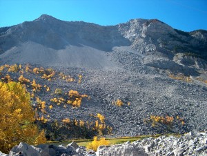
One example is the Frank Slide, in southern Alberta. In this rock slide, 82 million tonnes (30 million cubic metres) of limestone crashed from the summit of Turtle Mountain and buried a portion of the town of Frank on April 29, 1903. 70-90 people were killed, making it the deadliest landslide in Canadian history. The dimensions of the rock mass that fell were 150 metres (500 feet) deep, 425 metres (1,400 feet) high and one kilometre (3,280 feet) wide. The causes were several, including Turtle Mountain’s geologic formation made it unstable (weak, steeply tilted sedimentary layers), coal mining may have weakened the mountain’s internal structure, but the key triggers seem to have been a wet winter and bitter cold snap on the night of the disaster.
The Dynamic Equilibrium Model, used extensively by earth scientists, suggests that most of the earth’s landforms fit into the pattern of dynamic equilibrium (see Chapter 1). What typically happens is:
- A landform is stable (e.g. a mountain, a lake, a river). Turtle Mountain before the slide appeared stable … a town, Frank, had been built at the base.
- A destabilizing event occurs (e.g. a landslide, volcanic eruption, earthquake). On April 29, 1903, at 4:10 a.m. the landslide occured as 100+ million tonnes of rock crashed down within three minutes..
- A period of adjustment takes place (the landform changes its shape or characteristics) The shape of Turtle Mountain was changed, forever … so was the shape of the valley below, where much of Frank was buried under metres of rock!
- A new level of stability is established (a new landform is established). The current mountain/valley shape has stabilized over the past 100+ years. Vegetation has begun to grow among the boulders that buried the valley floor. The river has found a new channel.
Most landscapes are not on flat surface, but are on slopes (think about it … most of the land in the world is not perfectly flat … even Saskatchewan has a slight slope … rivers flowing downhill do move!)), thus gravity becomes an important factor. Because slopes are so common, they have been the object of much analysis. Study Pages 426-427 (4CE) / Figure 13.3, p.392 (3CE), “Slope mechanics and form” carefully and thoroughly. Read the associated text!
*** Know these terms and be able to locate them on a diagram of a slope (HINT: you will be tested on them!):
- Waxing slope – the upper part of a slope
- Free face – the middle of a slope
- Waning slope – the lower part of a slope
Know where you would expect to find coarse (upper part of the debris field) and fine materials (lower part of a debris field) around a slope.
Know where you would expect physical and chemical weathering, transportation and deposition on a slope.
- A slope is stable if its strength is greater than the denudation forces acting upon it – on stable slopes things don’t move.
- A slope is unstable if its strength is less than the denudation forces acting upon it – on unstable slopes things move!
I. Weathering
Weathering can be defined as processes which cause rock to disintegrate physically and/or decomposed chemically because of exposure to weather (heat, water, wind, etc.) at or near the earth’s surface. Weathering is “weather-related” … affected by heat (or cold), water (or drought), wind, etc. Thus it is exogenetic, as weather is powered by solar energy.
Note, weathering occurs close to where weather happens – at or near the surface. It does not happen deep underground.
Weathering is critical because:
- it provides material which may be transported, deposited and re-lithified (recompressed into rock) into sedimentary rock
- it provides material for soils
- it releases minerals for plants
A. Causes of Weathering
A particular rock may be exposed to weathering because:
- it’s already at/near the Earth’s surface
- it’s position has changed because of folding/faulting so it is now at/near the surface
- it is extruded onto the surface by volcanic activity
- overlying material has been eroded away, exposing the rock at the surface
- fluctuations in climate, for example greater rainfall, will result in greater weathering
- human activity – excavations etc. – may expose rocks, chemical pollutants create acids, etc.
B. Location of Weathering
Weathering only happens where “weather” can reach – in other words in areas close to the surface. The weathering zone is the area from the surface to the lowest point which “weather” (water, gases and heat energy from the atmosphere) reaches.
Weathering is most intense at the surface and diminishes with depth as the influence of atmospheric elements diminishes.
The weathering zone includes:
- soil (which is a direct product of the weathering of rock)
- regolith (a transition layer of weathered rock particles [stones, pebbles, etc.] and soil). See Figures 14.3, and 14.4, p.429 / Figure 13.4, p. 393 (3CE).
- bedrock – the unaltered rock. This is often called the parent material for the regolith and soil, because its mineral and chemical composition determines those of the other layers. The lowest point at which any weathering occurs is the weathering front.
C. Factors Influencing Weathering
Several factors influence the weathering of specific rocks, including:
-
Bedrock Properties:
Hard/solid bedrock with few joints/cracks (to let water in) is resistant to weathering. In contrast, soft/porous bedrock with many joints/cracks (to let water in) is less resistant to weathering. Granite – a hard rock with few joints, is very resistant to weathering. Sandstone, a softer, more porous rock with many joints, is much more easily weathered.
Bedrock composed of minerals that do not dissolve easily is resistant to weathering. In contrast, bedrock composed of minerals that DO dissolve easily and less resistant to weathering. Basalt, composed of mainly mafic minerals, does not dissolve easily; it resists weathering. Limestone, composed of calcium carbonate which dissolves quite easily, weathers relatively easily.
-
Geographic orientation:
Bedrock that faces north or east receives less heating/cooling effects from the sun, a key factor in weathering. Thus, in the Northern Hemisphere (including Canada) north- and east-facing rocks weather more slowly than south- or west-facing rocks. South- or west-facing rocks weather more quickly. Similarly, on most North American houses, shingles on the north and east sides last longer than shingles on south and west facing sides of the roof. Check it out on a home with older shingles!
-
Climate:
Note that physical weathering (see section D below) is most important in relatively moist cool climates. Note that chemical weathering (see Section E below) is most important in moist, warm climates.
-
Vegetation
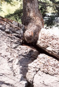
Plant roots grow in cracks in rocks. As they grow, they expand, slowly fracturing the rock; this is called root wedging. Plants also produce acids which gradually dissolve rock. Although this is not a direct effect of weather, it is included under the general heading of weathering.
D. Physical Weathering Processes
Physical weathering, also called mechanical weathering, happens when rock is broken up by physical processes. The disintegration of rocks occurs by processes that do NOT involve chemical change. NO chemical action is involved. There are several physical processes that cause weathering:
-
Heating/cooling.
Heat weathers rock material directly and indirectly. Temperature changes, for instance from day to night or when rock is exposed to fire, cause stress in rocks as they expand (when hot) and contract (when cold). Rocks heat quickly and cool quickly, so in regions with large diurnal (day-night) temperature changes (e.g. deserts, up to 100 degree day/night difference), rocks expand/contract rapidly. These stresses may cause fractures. Over time, particles or layers of rock break off. This is most important right at the upper surface of a rock. The process by which surface layers “flake off” as a result of this thermal weathering is referred to as exfoliation. This is often important in desert regions with large day/night temperature variations.
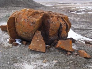
Frost shattering, Seven Persons, AB
-
Frost action.
Rock that has joints (cracks) in it, can allow water to penetrate. As this water in the joints thaws and freezes, the rock is gradually weakened. When the water freezes in the joint, it expands by 9%. This often causes rock to fracture and break. This is an important process in alpine and arctic environments where water may thaw during the day and then freeze at night. This is believed to have been and influential trigger in the Frank Slide disaster.
On slopes this typically results in talus slopes. At the bottom of cliffs, piles of rocks and boulders, talus, accumulates in sloped piles. These are sorted with the biggest bits at the bottom and the smallest fragments at the top. These are very common in the North American Rocky Mountains, the Alps, and Andes.
See Figure 14.7 and 14.8, p. 431 / (Figures 13.6-13.8, pp. 395-6 (3CE)).
On a flat surface, a vast area of broken rock called a felsenmeer develops.
-
Crystallization:
In arid climates, during long dry periods, water deep within rock is drawn to the surface and evaporated. This water often contains dissolved mineral salts or halite, which grow and expand when they dry, fracturing rocks. This is common in arid areas, where solar energy draws moisture from beneath the surface to the surface for evaporation. The water evaporates, leaving the (previously dissolved) salt crystals behind. See Figure 14.9, p. 432 (Figure 13.9, 3CE, p. 397), “Physical weathering in sandstone.”
-
Wedging:
Plant roots can penetrate cracks in rocks. As plants grow, their roots grow, causing the rock to fracture. Figure 14.5 and 14.6, p.430 (Figure 13.5a, 3CE, p. 394), “Organic physical weathering.” (see the picture of roots above)
-
Pressure release:
When great weights are removed from rocks (for instance at the end of the last ice age, when the ice sheets melted), rocks “rebound” and may crack or break. The Canadian Shield is still rebounding from the ice age, slowly rising a little bit each year. As the Canadian Shield slowly rises (millimetres per year), the rocks may crack and split. Pressure realease also happens when overlying layers are eroded away, exposing rock that was once under great pressure from overlying rock. Over time, sheets of rock break away from the exposed rocks along the fractures. Rock typically flakes off in sheets, through the process of exfoliation.
** Notice that many of these physical weathering processes require water and moderate heat (ideally above freezing during the day and below freezing at night). This is why these processes are most important in cool, damp climates (like the midlatitudes – most of North America and northern Europe). In really warm (tropical) or really cold (Arctic) climates, freeze-thaw processes don’t occur. In really dry climates (deserts) water doesn’t exist for freeze-thaw, or wedging processes, but thermal heating does occur.
E. Chemical Weathering Processes
Chemical weathering refers to several chemical processes that convert hard, massive bedrock into fragments. Chemical weathering is most pronounced in humid, warm environments.
-
Hydrolysis
When hydrogen (H+) ions chemically react with carbon dioxide (CO2) molecules and other minerals (especially felsic minerals found in rocks like granite), the rocks are broken down into silica (quartz) and clay. The result, when the weathered materials are washed downstream, are clay deposits and sand (quartz crystals). This is one of the processes that weathers granite and basalt (but it is SLOW!).
-
Oxidation
Oxygen (O) and water combine with a variety of minerals to form “oxides.” For instance, rock with iron in it, can literally “rust” when exposed to oxygen. This produces the red rocks (hematite) you may have seen. As iron rusts, it breaks apart. This gives the affected rocks a reddish-brown coloration on the surface which crumbles easily and weakens the rock. Many other metallic ores and minerals oxidize and hydrate to produce colored deposits. Weathering or rock decomposition often happens as oxidation occurs. See Figure 14.13, p.435 (Figure 13.13, 3CE p. 400), “Oxidation processes …”
-
Dissolution
Water can dissolve a number of minerals easily. For instance ordinary salt, sodium chloride (NaCl), when dissolved in water, can then dissolve at least 57 of the naturally occurring elements and their associated elements. Rainwater easily dissolves soluble minerals, such as halite or gypsum, but can also dissolve highly resistant minerals such as quartz, given sufficient time.
Carbonation is a specific form of dissolution, which occurs when rocks that contain carbon (like limestone, also known as calcium carbonate [CaCO3]) react with water. Carbonic acid results. Acid water is also produced by water dissolving rotting vegetation, and by water washing out acid pollution from the atmosphere (acid rain). The acid “eats the rock”, dissolving it away. In well-jointed limestone produces a dissected limestone pavement.
** Note that these chemical processes often require water to occur. The chemical reactions involved happen more rapidly in warm environments. Therefore, chemical weathering is most important in warm, moist regions (like the tropics). In dry environments, there is often not enough water for the chemical reactions to occur. In cool climates, chemical reactions occur very slowly.
F. Landforms created by Weathering
Landscapes where weathering is the dominant gradational process often create these landforms:
Residual blocks of bedrock which stand above the surrounding terrain, usually on hilltops, are called tors. These are not loose rocks, but outcops of bedrock, heavily weathered by phsyical and/or chemical processes.
Limestone areas which are heavily chemically weathered are called “karst.” Karst regions often have well developed limestone caves or karst towers. They are named after a region in Slovenia, Montenegro ,and Croatia, where this type of landscape is common.
Regions of karst in North America include the Mammoth Caves (Kentucky), Carlsbad Caverns (New Mexico), Oregon Caves (Oregon), much of the Yucatan Peninsula (Mexico), Puerto Rico, and in the Rocky Mountains of B.C. and Alberta (Maligne Canyon, Jasper, is believed to be the most extensive karst in Canada). Karst is also found throughout Europe including southern France, in the Middle East (Lebanon), and throughout Asia (e.g. Zhangjiajie National Forest Park).
For karst to develop, these conditions are essential:
- limestone or marble (which is metamorphosized limestone) with high calcium carbonate (CaCO3) content (this is easily dissolved by acidic rainfall or water percolating through an acidic environment, such as decaying vegetation)
- joints/cracks in the limestone or marble, to allow water to penetrate the rock
- a water table well below the surface
- much vegetation to produce acidic litter
- much precipitation
Note that water (H2O) is not always chemically stable. Often the molecules tend to dissociate to produce positively charged hydrogen ions (H+) and negatively charged hydroxyl ions (OH-). The relative amounts of these ions determines whether water (and thus soil) is acidic or alkaline. This is measured on the pH scale, which ranges from 0 – 14. Water/soil with a pH from 0 – 7 is acidic; acidic water weathers rock fairly readily. Acidic conditions are common in regions of high rainfall and lush vegetation. Rainfall is naturally mildly acidic (pH 5.7-7.0). Human-produced air pollutants and some natural processes (such as volcanic eruptions) can make precipitation much more acidic (acid rain). Karst is the result!
In contrast, water/soil with a pH from 7-14 is alkaline; alkaline water weathers rock less easily. Alkaline conditions often exist in drier, less lush conditions. No karst!
When acidic water penetrates flat limestone surfaces, a karst or limestone pavement often develops – a smooth layer of limestone is cut by deeply eroded cracks (grikes), shallow streams (runnels), and depressions (solution basins). The unweathered pieces between these features are called clints. This is very common on flat surfaces in the Rocky Mountains.
On a larger scale, a pattern of sinkholes can develop where acid water has weathered deep basins. One of the better known Canadian examples is in Wood Buffalo National Park, in northern Alberta. See Figures 14.16-19, pp. 437-439 (Figures 13.16-18, & 13.20, 3CE pp.402-405).
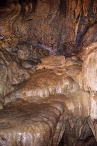
Limestone caves are dramatic features created underground. Study Figure 14.22 p. 440 (Figure 13.22, 3CE, p. 406), “Cavern features.” *** Know:
- stalactites, (formed by calcium carbonate saturated water dripping from a cave roof – mnemonic help: stalactites hold “tight” to the ceiling)
- stalagmites, (formed by calcium carbonate saturated water dripping onto a cave floor – mnemonic help: stalagmites grow up “mighty” strong)
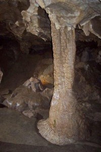
- columns (formed when stalactites and stalagmites join as floor to ceiling pillars)
- drip stones or flow stone (formed by calcium carbonate saturated water, flowing on a cave floor or horizontal ledge), and
- drip curtains (formed by calcium carbonate saturated water, flowing on a cave wall or vertical surface).
Visit a virtual cave … visit this website for a clickable tour of everything “cave-ish” … hotspots to click on everywhere! Don’t miss it
Tower karst occurs when a huge region of limestone is weathered away, leaving only isolated “towers” of resistant stone to mark the original rock surface. See also Zhangjiajie National Forest Park (China) and Bulusaraung National Park (Indonesia)
II. Mass Movement or Mass Wasting
STUDY Figure 14.24, p. 443 (Figure 13.24, 3CE, p.409), “Mass Movement Classification”! This will help you a lot! (and may be on the exam!)
Mass wasting or mass movement is downward movement of soil, regolith, and/or bedrock under the influence of gravity. The Frank Slide is a classic example.
Mass movement works to break down slopes and provide material for erosion, transportation and deposition.
All mass movement happens on slopes (after all, by definition, gravity has to be involved). On a slope, the driving force (gravity) is usually balanced by the resisting forces (friction and shearing) – things stay put.
However if you change something – like the slope angle, moisture content, movement (earthquake), weathering (like freeze/thaw processes), or human activity – materials start to move!
The resisting force depends on the cohesiveness/strength of the slope material. Sand has little cohesiveness. Soil/clay has moderate cohesiveness, depending on moisture and mineral content. Rocks range from shale and mudstones (low cohesiveness) to granites and basalts (high cohesiveness).
This means that sand will move on very shallow slopes. In contrast, rocks like granite, can be stable on vertical slopes.
Resistance is also related to rock structure. Strata parallel to the slope may shear more easily than strata at right angles. This was the case on Turtle Mountain, Frank. The sedimentary layers were steeply tilted, parallel to the slope. Thus they can easily slide on one another.
A great introduction to landslides and mass movement is found here.
A list of major landslies is here: List of landslides
NASA has an up to the moment “Global Landslide Viewer” (Info, Viewer)
A. Types of mass movement:
-
Rockfalls
On steep rock cliffs created by faulting or erosion, pieces of rock may simply fall and accumulate at the foot of the slope as talus or scree slopes. Freeze-thaw weathering processes, in particular, are responsible for freeing fragments or large blocks which fall as rockfalls. Rockfalls are dry – just rock.
Talus slopes, cause by rock falls, tend to be “sorted” with larger blocks at the top and smaller fragments at the bottom.
These are small-scale events. One or two rocks are falling all the time, over a long period of time.
These talus slopes are very common in the Rockies. (See Figure 14.25, p.444 (Figure 13.25, 3CE p. 409) “Talus slope”)
2. Debris avalanches
When rock, debris, and soil move downhill at high speed they are called debris avalanches. Often these are associated with ice/water or snow that provide lubrication for debris movement. They include rock, water, snow, debris – everything!
In alpine areas, avalanches can be caused by a sudden release of melting snow and ice, mixed together with rock material. See Figures 14.26, p. 444 (Figures 13.26-27, 3CE, p. 410).
e.g. Peru, 1970 – a severe earthquake (7.7) caused a snow avalanche which mixed together with loose rock and soil to produce a huge avalanche which travelled down a valley at over 500 kmlh, burying the village of Yungay and 17,000 people. The rock and ice travelled 14.5 kms and fell 3.7 kms in less than 4 minutes.
e.g. Howe Sound, BC – snow melt and heavy rains annually produce great amounts of runoff, which often pick up rock material and vegetation. Over the years several bridges have been destroyed, causing several deaths. Consequently major engineering projects have been undertaken to try to control the runoff and debris floods.
Frequently debris avalanches are associated with volcanic activity, for example at Mt. St. Helens (1980). This was the largest debris avalanche recorded in historic time.
3. Landslides/rockslides
Landslides or rockslides occur when there are sudden rapid movements of large amounts of bedrock or regolith, NOT saturated with moisture (or it would be a debris avalanche). They are sudden and large-scale (unlike rockfalls), but do not include water/snow/ice (like debris avalanches). Often this occurs along well-defined planes, causing rock to slide downhill. Rockslides are common in heavily glaciated areas, where glaciers have carved deep, steep-sided valleys.
e.g. Turtle Mountain (Frank) Slide in S.W. Alberta, 1903. An enormous mass of limestone (30 million cubic metres, 82 million tonnes) slipped 1000 metres downhill, buried part of a town, climbed 120 metres up the opposite side of the valley. 70 people were killed. The slide may have been triggered by coal mining activity that weakened the already precarious rock structure. See Focus Study 14.1, “Frank Slide …” pp. 445 (13.1, 3CE, pp. 412-413).
Obviously an understanding of bedding planes and geologic structure is very helpful for predicting where rockslides might occur!
4. Earthflows
An earthflow occurs when a mass of soil, regolith or weak clay or shale becomes saturated with water (heavy rain, snowmelt, flood), it may move downhill relatively rapidly (over the course of a few hours); but not as a sudden, destructive debris avalanche. The material moves sluggishly, leaving step-like scarps (low cliffs) and terraces at the head, and a bulging toe (see Figure 14.24, p. 443, (Figure 13.24, 3CE, p. 409), “Mass Movement Classes”).
Earthflows are most common on grass or forest covered slopes that have been saturated by heavy rains, snowmelt, or ground water. The vegetation roots help to control the flow by holding the soil together.
Earthflows frequently block road/railway lines, destroy buildings, or at least dislodge foundations.
e.g. Palos Verdes Hills, L.A. County: 160 hectares of land moved 20 metres over 3 years, causing $10 million damage. The problem was saturated soil caused by watering gardens and the use of cesspools. The 150 homes affects were discharging 115,000 litres of water per day!
5. Mudflows
Mudflows happen when certain materials become saturated (especially very fine-grained clays and silts). These sediments, when saturated, behave almost like a liquid, flowing downhill rapidly like a river of mud. (see Figure 14.24, p. 443, (Figure 13.24, 3CE, p. 409), “Mass Movement Classes”).
Mudflows are most common in:
- deserts and arid areas, where vegetation does not protect soil on slopes and local, very intense rainstorms provide water faster than the ground can absorb it. Surface water runoff mixes with sediment to form mud, which moves downhill quickly.
- areas of active volcanoes, where rain or melting snow turn ash into mud.
- areas made up of sand/silt/clay with no solid bedrock
- they can be more common where trees and other vegetation with deep roots (that hold material together) have been removed (for instance where areas have been clear cut logged).
e.g. Mt. St. Helens (USA, 1980) caused mudflows which travelled 120 km and deposited 50 million cubic metres of sediment in the Cowlitz and Columbia Rivers. This is the world’s largest historic landslide (in terms of volume) . The total volume of material displaced was 2.8 km3.
e.g. L.A. County has had real problems with this because real estate development is occurring an very steep clay and silt slopes. As roads and foundations have been excavated deep into the regolith, soil and debris has been piled in embankments. This construction, combined with occasional brush fires that remove the vegetation helping to hold the soil together, has resulted in several destructive mud flows in recent years.
e.g. Vargas mudslides, due to heavy rains in Vargas State, Venezuela, in December, 1999, caused tens of thousands of deaths.
6. Rock/Talus Creep
In many alpine areas, talus (loose rock) accumulates rapidly on top of small masses of glacial ice. Ice moves slowly downhill, carrying the talus with it. These “rock glaciers” can carry tremendous quantities of rock downhill.
7. Soil creep
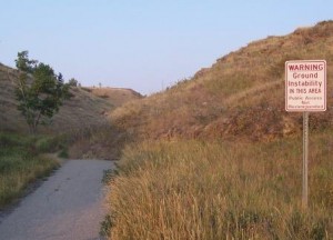
Soil creep is the slow downslope flow of surface soil, saturated with water. Saturated soil can move very slowly downhill simply as the result of gravity if the surface is not protected by vegetation. Typically soil happens because of the influence of animals or deforestation. Often “lobe” shaped patterns develop. (see Figure 14.24, p. 443 (Figure 13.24, 3CE, p. 409), “Mass Movement Classes”), and Figure 14.28, p. 446 (Figure 13.29, 3CE, p. 411), “Soil creep …”). The two examples are just down the road from my home in Lethbridge, AB:
A specific form of soil creep is solifluction. This happens in environments that experience freeze-thaw action. As soil freezes it rises at right angles to the slope surface and as it thaws it fails straight down because of gravity. Gradually it moves downhill. It is characterized by the slow movement of soil material downslope and the formation of lobe-shaped features.
8. Scarification
Human induced mass movement is referred to as scarification. Every human slope disturbance — a highway cut, housing construction, subdivisions, mining, even school construction — affects weathering. Large open pit mines are among the most substantial “mass movement” effects of humans, called scarification.
In Canada, open pit
- coal mining occurs in south-eastern BC, central Alberta and Nova Scotia
- diamond mining in the North West Territories
- gypsum in Nova Scotia
- other ores and minerals in many parts of the country
The Athabasca tar sands in northern Alberta were first developed as strip mines; the upper 40-100m of soil and sand were removed, and essentially steam-cleaned.
The environmental affects of large-scale scarification are matters of considerable debate:
- the Cheviot Mine, on the boundary of Jasper National Park, threatens a UNESCO world heritage site
- the infamous Sidney, NS tar ponds are the by-product of coal mining
- several largescale deaths of birds on toxic lakes in the Athabasca oil sands highlights the dangers of open pit mining.
Read your text, pp. 446-447, (pp. 410-415, 3CE). See Figure 14.29, p. 447 (Figure 13.30, 3CE, p. 414 ), “ Scarification.”
III. Erosion
Weathering refers to processes at/near the earth’s surface which physically or chemically break down rock.
Mass wasting refers to the downward movement of soil, regolith and/or bedrock because of gravity.
Erosion is a general term for the removal of rock or mineral particles from exposed surfaces by water, air or ice, or by other particles carried by these agents.
A. Source of Particles
In order for erosion to occur, loose rock or mineral particles have to come from somewhere! The main processes that produce these particles are:
-
Weathering
Particles are broken into smaller particles primarily by weathering. Weathered materials, especially fine materials like soil, sand, and silt are very susceptible to erosion. In general, the smaller or lighter the particle, the more easily it is eroded or moved.
-
Quarrying
Wind, water, and ice, themselves, can detach particles (however, often the suspended particles are more important – see abrasion). When ice freezes to a surface, especially in cracks, it expands and “pluck” weak fragments of rock. Rapidly running water and strong winds are also able to remove particles.
-
Abrasion
Material transported by water, air or ice may cause friction or collide with other materials and cause particles to detach.
For example, the major erosive agents in most streams/rivers are the suspended sediment, pebbles and other material carried along. The major erosive agents associated with glaciers are the pebbles, rocks and boulders carried along in the ice which scour the glacier’s bed. Although wind causes some detachment, air with suspended sediment (such as sand) is much more erosive.
The effectiveness of these agents in eroding material is related to
- the size of the particles being carried: the bigger the particle, the more erosive it is – a boulder pushed by a stream is more erosive than a small grain of sand!,
- the number of particles in the water, ice, or air. The more particles, the more erosive it is – on a windy day, the wind itself may hurt, but if it’s blowing lots of sediment – OUCH!
- the speed of the particles. The faster the water, ice or air is moving the more erosive is – that dust storm hurts more, the faster the wind is blowing!
-
Rainsplash (video)
The impact of raindrops is a surprisingly powerful force in loosening particles for erosion. Its impact is directly related to the frequency and duration of rain, how large the drops are, with how much force they hit, and how much vegetation cover there is to protect the soil.
e.g. a torrential rainstorm may disturb as much as 225 tonnes of soil per hectare. On a slope, much of this may be removed. Heavy rains also tend to seal natural pores in the soil, causing greater runoff and greater erosion of soil.
B. Moving Particles
Once particles are loosened, they are able to be moved. Forces which encourage particles to move include:
-
Gravity
Particles on a slope tend to move down slope. There is a “critical angle of sliding” at which point the forces of gravity overcome the forces of friction, and a particle moves down slope.
-
Fluid Forces (Water & Air)
Water and air exert both a horizontal “drag” force on a particle, as well as a vertical “lift.”
- the horizontal drag or “push” force, if it is sufficient to overcome the resistance of friction and cohesion, will cause the particle to move. The strength of this force is directly related to the velocity of the water/air (the faster the flow, the stronger the force), the density of the medium (water, which is denser than air, has a stronger force), and the sediment load (more sediment results in a stronger “push”).
- the vertical lift force is directly related to the amount of turbulence and buoyancy in the water/air. Turbulence causes the particles to rise off the surface, minimizing the effects of friction and cohesion, allowing the particle to “float” and be carried along easily. Irregular (rough) surfaces tend to cause more eddies and turbulence. Mediums moving at high velocities are also usually more turbulent.
C. Processes of Transportation
Particles can be transported in a number of ways:
-
In Suspension
Particles are carried along by the agent (water, air or ice) and do not touch the bed. Particles are not dissolved, but carried along (think about small dirt/dust particles that are carried along in a river …)
-
In Solution
Particles are dissolved in water and carried along as chemical compounds in the water. Think about salt in the ocean …
-
By Saltation (yes, an odd word for it – it has nothing to do with SALT!)
Particles ‘bounce” along the bed. This often causes more erosion by causing other particles to be detached and entrained, both from the bed and from the particle itself. (which is why particles tend to become smaller and rounder during the process of erosion). Think about pebble transport by rivers, sand drift over desert surfaces, soil blowing over fields, or even snow drift over smooth surfaces such as those in the Arctic or Canadian Prairies.
Particles never leave the bed, but are rolled or slid or shuffled along the surface Again, this often causes more erosion by causing other particles to be detached and entrained.
D. Factors Affecting Transport
The transport of particles by these processes is affected by:
-
particle size and weight (mass)
– larger, heavier particles tend be more likely transported by traction and travel slowly. They travel shorter distances and cause much erosion both to the bed and to themselves.
– smaller, lighter particles are more likely transported in solution or by suspension; they travel more quickly and further distances. They tend to cause less erosion either to the bed or to themselves.
Because of this, eroded material tends to be sorted:
– larger, heavier material closest to the source (e.g. boulders, near a river’s source);
– small, lighter material furthest from the source (sand, silt, at a river’s mouth).
2. particle shape
Smooth particles tend to travel faster and further than irregular or rough one (friction). Thus previously eroded material (e.g. a smooth stone beach) is more easily eroded than newly weathered material (a talus slope of weathered, angular stones).
3. nature of the agent:
– air tends to move only smaller, lighter particles, but quickly and great distances.
– water tends to move particles of all sizes; small ones quickly and long distances; larger ones slowly, for shorter distances.
– ice (glaciers) tends to move all sizes (even very large particles), but all at equal speed (usually very slowly)
E. Deposition
Eventually most transported material is deposited …
-
Why?
a. change in velocity – if the velocity of air/water drops, the ability of the medium to transport particles drops. For instance, strong wind carrying dirt deposits the sediment when the wind speed drops. Rivers carrying sediment deposit it when the water speed slow down. You notice this effect in the fall … where do leaves accumulate … in sheltered areas where there is little wind speed.
b. change in friction – if the roughness of the surface increases, the ability of the medium to transport particles drops. For instance, wind blows sediment easily over smooth fields. But the wind will deposit the sediment if it encounters a windbreak … a row of trees or other vegetation. In the Prairies, win breaks are an essential part of the campaign against wind erosion of soil.
c. change in the effect of gravity – if the slope of a surface decreases so does the ability of water to transport particles. Steep, fast-flowing rivers can carry much sediment with little deposition. However if the slope decreases, the river speed decreases, and deposition can occur.
d. change in cohesiveness – if dry particles are moistened, the ability of air to transport particles is reduced. Really dry soil is more easily eroded than moist soil.
e. flocculation – when fresh water rivers carrying much silt and clay mix with salt water (at the river mouth), the salt chemically reacts with the fine mud and clay particles transported by the fresh water rivers. The mud and clay particles “agglomerate” — glom together –into larger particles which settle out. Thus, where rivers drain into oceans there are often huge sediment deposits (islands, sand bars, deltas). These deposits are partly the result of the fact that the river’s velocity is decreased and partly the result of this chemical process of flocculation. (Flocculation is a general term for chemical processes that cause particles to “glom” into larger units and settle out … a variety of these chemical agents are used in waste treatment, for instance, to remove waste products from water …)
-
Sorting
Most deposited material is sorted by weight and size because of the relative ease with which it can be transported.
e.g. in most river systems large rocks are found near the headwaters, fine sediments near the mouth. It is difficult for a river to transport a 2 tonne boulder very far from its source! A river can transport tiny silt and clay particles thousands of kilometres!
e.g. on beaches, larger rocks are found at the end from which waves come; fine sand is found at the far end. Waves moving along a beach can push fine sand along to the far end. The waves cannot push the 2 tonne boulders!
F. Landforms of Erosion and Deposition
-
Erosional Landforms
Erosion tends to leave behind resistant materials, often in unique shapes (eg. volcanic necks, hoodoos)
Erosion tends to accentuate joints and weaknesses in rocks, creating larger cracks or gullies.
As we will discuss later on, rivers, glaciers and wind we will discuss specific landforms.
-
Depositional Landforms
Landforms created by deposited materials are classified as either
a. Active Landforms
These are in the process of being created at the present time: material is currently being added to them by streams (bars, beaches, etc.) wind (dunes, etc.), or ice (active moraines).
These are in the process of change and may or may not exist for long periods of time!
b. Relict Landforms
These were created by processes in the past which are no longer actively affecting them.
Under other circumstances, erosional processes cause depositional features that have become stabilized.
e.g. river terraces are flat “steps” above a river which were once flood plains. As the river has cut a deeper valley, however, they are no longer active.
e.g. raised beaches were once active beaches at sea level, but now are well above sea level. Either sea level has dropped or the land has been raised.
e.g. vegetated sand dunes – sand dunes which have stabilized because of climate or vegetation changes
G. Erosion and Human Activity
Much human activity increases erosion. Especially serious are soil erosion problems caused by clearing vegetation for agriculture, forestry, residences, etc. The government of Ontario has a great “Fact Sheet” on soil erosion.
In some instances, people have actually reduced erosion. For instance on many coastal areas, beach/cliff erosion has been reduced by engineering projects.
Worth reflecting on …
Check out this video clip “Does science threaten belief in God: A Random Process?“:
Again, this may stretch your thinking … that’s OK! It’s great to think bigger about who God is and how He can work in the world …
The American Scientific Affiliation and Canadian Science and Christian Affiliation are fellowships of men and women in science and disciplines that relate to science who share a common fidelity to the Word of God and a commitment to integrity in the practice of science. A really helpful article is this one … here’s just a teaser (follow the link for the whole article — it is worth it!)
About Science And Faith: An entry-level approach to science-Christianity Studies
The rise of science in the seventeenth and eighteenth centuries was accompanied by a diminishing influence of the Church and the Bible in western society and the turn to a secular society where government, education and medicine are for the most part independent of church structures and beliefs. Scholars continue to debate the fine points of how this has played out in various places. Americans have seen science-religion questions become fodder for the media in such tuf-of-wars as the Tennessee Scopes trial (1928) and the recent Dover PA School Board legal episode (2005).
Today, some American Christians feel endangered by the results of scientific study and the philosophical conclusions that some non-Christians have drawn. Others include negativism toward science as part of a political package in the culture wars. However, many Christians regard science as a gift from God that can be of enormous value to the human condition and are working to use science in a God-honoring way in medicine, agriculture and innumerable other areas.
This introduction will first offer some basic consideration that are important to any discussion of particular issues. As many questions have roots in the past it is important to take into account these earlier responses before we jump into the present .
In examining science-faith issues, we must appreciate the fact that different people may come to different conclusions when faced with the same evidence and that the evidence (or the way that we assess the evidence) may change over time. As one digs, what may appear clear on the surface becomes more complex and sometimes unsolvable based on the information at hand. Humility and reserving judgment are valuable virtues.
It would be much easier to function as though modern science and the Bible had nothing to do with each other except in matters involving morals and ethics, but that would ignore what historian Colin Russell describes as “the battery of historical data which point to a massive mutual debt between science and Christianity.” Cross-currents: Interactions Between Science & Faith (1985), p. 20.
This material is offered to students of all ages to help you to become informed, make decisions and strengthen your faith.
Whether you are new to the subject or an “old hand” finding this page for the first time it is important that you develop a grasp of the nature and use of both Scripture and science before plunging into the issues that capture our mind today. OK, now read on … Relating Science and Christianity (click the link!)
How do you feel about these ideas? Do you agree? Feel free to discuss this quote on the course discussion site (see the syllabus for details …)
To Review …
Check out the resources at www.masteringgeography.com
This page is the intellectual property of the author, Bruce Martin, and is copyrighted © by Bruce Martin. This page may be copied or printed only for educational purposes by students registered in courses taught by Dr. Bruce Martin. Any other use constitutes a criminal offence.
Scripture quotations marked (NLT) are taken from the Holy Bible, New Living Translation, copyright © 1996. Used by permission of Tyndale House Publishers, Inc., Wheaton, Illinois 60189. All rights reserved.

