Chapters 9 (part) and Chapter 15a/14a
Water! Groundwater, River Systems and Landforms
Geosystems 4CE, pp. 256-265, 453-486 (Geosystems 3CE, pp. 246-254, 419-449)
“Give thanks to the Lord of lords.
His faithful love endures forever.
Give thanks to him who alone does mighty miracles.
His faithful love endures forever.
Give thanks to him who made the heavens so skillfully.
His faithful love endures forever.
Give thanks to him who placed the earth on the water.
His faithful love endures forever.
Psalm 136:3-6 NLT
In this lecture we will consider the role of water in shaping the landscape. The general term for the study of water in the natural environment is hydrology.
**There is a video version of this lecture here: https://youtu.be/X0tgiR0IvyY
**The exam is based on the content in these notes, so please print them off to study from.
This section will focus on groundwater (from Chapter 9). The next section will focus on surface water — rivers and river systems (Chapter 15 in 4CE, Chapter 14 in 3CE). Make sure you do read 15b for the midterm, too.
Water is a powerful agent for shaping the landscape.
I. Groundwater (Chapter 9, 4CE, pp.256-265,(3CE, pp. 246-254))
The Government of Canada has an excellent groundwater website, click here
so does the U.S. Environmental Protection Agency has an excellent ground water site, click here.
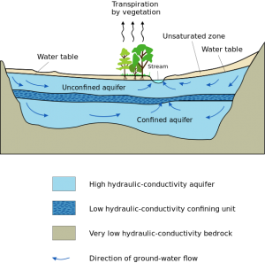
Groundwater refers to subsurface water that exists within the rock or soil. The upper layer of this saturated zone is called the “water table.”
The true position of the water table is shown by the level of standing water in a well deep enough to go below the water table. If you dig a well that goes below the water table, the water level in the well will be at the water table level.
Generally the water table rises and falls with surface topography. It is not “flat.” It rises under hills and drops under valleys. However the rises and dips are not as dramatic as the surface topography.
Note the water table is not always a constant depth beneath the surface. The water table is normally closest to the surface in valleys and furthest from the surface on hilltops.
The water table may also rise and fall in response to climatic changes, and human use of groundwater. In dry seasons, or with much human use, the water table will drop. In wet seasons, or with little human use, the water table may rise.
A. Groundwater Movement
Study Pages 258-259, “groundwater” (4CE) or “groundwater characteristics” (Figure 9.15, 3CE, pp. 248-9)
Because the landscape is rarely perfectly flat, water in the ground flows, because of gravity. It will flow downslope.
If the lower levels of soil or bedrock are nonporous or impermeable (in other words, there are no holes/pores in the rock; water cannot penetrate it), groundwater moves by interflow through the soil near the surface. In this circumstance, water cannot sink down into the bedrock, so it is forced to flow through the soil near the surface. Impermeable or nonporous bedrocks include many igneous rocks, like basalt and granite, and many metamorphic rocks like shale. It is, understandable, pointless to drill a well into nonporous rock! There is no groundwater in the rock!
If the lower levels of soil or bedrock are porous or permeable (in other words, there are holes/pores in the rock; water can penetrate it), groundwater flow occurs through aquifers. Aquifers are layers of bedrock that allow water to flow through them. Often sedimentary rocks (limestone, sandstone) do allow water to flow through (very slowly, of course!).
Springs are natural flows of groundwater which emerge at the earth’s surface. For instance, when groundwater, flowing slowly through an aquifer, reaches a valley side, it often emerges at the surface as a spring. Water flow through aquifers several metres or tens of metres below the surface. When the water reaches a valley it emerges as a spring in the valley wall.
This is true in
- many Atlantic regions, where more permeable layers underlie more solid layers;
- the prairies; for instance in the Blackmud Ravine or the North Saskatchewan river valley, Edmonton, AB
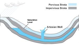
 Sometimes groundwater gets trapped under a layer of solid, nonporous rock (called an aquiclude). The water would like to rise to the “potentiometric surface” (the “potential” level of the groundwater … the level to which groundwater would rise if it were free to do so). But it cannot because it is sealed beneath a layer of solid bedrock. If there is a crack in that layer of bedrock, or you drill a hole through the bedrock. the water can rise up. The water rises in a naturally flowing well called an artesian well. An artesian well is a well whose head (top) lies below the normal water table (or potentiometric surface). (see Pages 258-249 (Figure 9.15, pp. 248-249 “groundwater characteristics” (3CE)). Because these types of self-flowing wells are common (apparently) in the Artois region of France they are called Artesian wells.
Thermal Springs and geysers occur as groundwater comes in contact with hot rocks at a thin point in the earth’s crust. As the water is heated it rises as hot water (hot springs) or as a geyser (steam). The Rocky Mountains, primarily limestone and sandstone, and crisscrossed by many faults, allow ground water to penetrate to great depths. Because of the faulting, magma and super-heated rocks are often not far (in geologic terms) beneath the surface. This allows groundwater to come in contact with very hot rocks beneath the Rockies. The result are hot springs at Miette (Jasper), Banff, Fairmont, etc. Further south, similar formations cause the geysers in Yellowstone National Park (More than 75% of the world’s geysers, including Steamboat, the world’s tallest active geyser, are in Yellowstone). Often hot springs and geysers have a distinct sulphuric odor, because the hot water dissolves sulphur in the rock, raising it to the surface. As the water evaporates, the sulphur is left behind.
B. Groundwater Withdrawal
People tend to like to withdraw groundwater! People have consistently used groundwater for consumption and for irrigation. Groundwater use (overdrafting) has increased tremendously as people have settled in arid regions (the southern Canadian prairies, Okanogan Valley, Arizona, Nevada), and demand has intensified (more irrigation and intensive agricultural, residential, and industrial use).
In areas with high precipitation nature recharges the groundwater adequately. So, even though people are using more groundwater, enough new water comes back into the system.
But in arid areas, with low precipitation, problems develop! When demand exceeds supply (recharge), the water table drops because there is less and less groundwater. As a consequence, wells must be drilled deeper to reach the groundwater; in some places (e.g.,California, Texas, and India) the water table has dropped hundreds of feet because of extensive well pumping. The solution is usually to sink more, deeper wells (78,000 new wells are drilled per year in India) – but that’s a short-term answer! Ultimately there is less and less water.
Consider the crisis in California: California drought: Drilling deeper in the hunt for water
This creates problems! (Read text, “Overuse of groundwater” 4CE, pp. 260-262; 3CE, pp. 249-252)
With climate changing, here are the places in Canada increasingly vulnerable to drought.
C. Pollution
- leeching of chemicals from landfills (leachate), agricultural activities (including crop production and livestock production), pesticides, etc.
- waste water runoff – chemicals, road salt, intensive livestock operation refuse, mine tailings, oilsands tailings ponds, etc.
- in coastal areas, when fresh water is removed, salt water percolates in, destroying soil fertility and rendering wells worthless.
- in areas now dependent on groundwater, current levels of activity cannot be sustained without dramatic intervention … building reservoirs, etc.
 Groundwater quality and pollution has become a critical issue throughout the world. Clean drinking water is an essential for healthy human and biotic survival!
Canadians across the country are growing increasingly anxious about what is happening to their water supply. Deaths due to contaminated drinking water in 2000, in Walkerton, Ontario, have challenged government agencies to monitor drinking water quality more closely and to consider developing more stringent guidelines for noxious industries, from industrial plants to intensive agricultural operations.
-
- In August 2014, the Mount Polley mine tailings pond partially breached releasing 10 million cubic metres of water and 4.5 million cubic metres of slurry into Polley Lake, BC, with effects on the lake and groundwater in the surrounding area..
- Love Canal, New York, was one of the most widely publicised examples of groundwater pollution. In 1978, residents of the Love Canal neighbourhood in upstate New York noticed high rates of cancer and an alarming number of birth defects. This was eventually traced to runoff from an industrial landfill which had infiltrated the water supply. Eight hundred families were reimbursed for their homes and moved.
In Canada, Environment Canada has identified Groundwater contamination risks including:
- Waterborne Pathogens
- Algal Toxins and Taste and Odour Problems
- Pesticides
- Persistent Organic Pollutants and Mercury
- Endocrine Disrupting Substances
- Nutrients – Nitrogen and Phosphorus
- Aquatic Acidification
- Ecosystem Effects of Genetically-Modified Organisms
- Municipal Waste Water Effluents
- Industrial Point Source Discharges
- Urban Runoff
- Landfills and Waste Disposal
- Agricultural and Forestry Land Use Impacts
- Natural Sources of Trace Element Contaminants
- Impacts of Dams/Diversions and Climate Change
Landfills and waste disposal are one of the greatest threats to groundwater in Canada.
Check out:
- the U.S. Environmental Protection Agency on groundwater/drinking water
D. Subsidence
As groundwater is removed, land may sink. In combination with rising sea water levels (thanks to global warming and melting ice caps), disastrous results can occur!
e.g. New Orleans: 80% of the city is below sea level — some areas as much as 3 metres below! Groundwater and oil and gas withdrawal — coupled with the lack of new sediment being deposited by annual flooding of the Mississippi River (nor more flooding thanks to dikes and levees), means the city will continue to sink. The city is protected from the sea by a complex series of dikes … however as Hurricane Katrina showed, these can be breached. What then??? Bad things! Note that this was NOT a surprise! Scientists have been predicting such an horrific event for years … In March 2002, the Natural Hazards Observer reported that:
Research conducted by the U.S. Geological Survey determined that New Orleans particularly suffers from the effects of local subsidence and a worldwide rise in sea level, making it especially vulnerable to a coastal storm. Today most of the city is below sea level, and some areas are as much as 10 feet lower than sea level. Levees along the Lake Pontchartrain shoreline that protect New Orleans from flooding are designed to withstand only a category 3 hurricane storm surge. It would cost approximately $100 million to raise the levees surrounding the city an additional foot, but there is currently no funding for protecting against accelerated sea-level rise. Hurricane Andrew in August 1992 skirted New Orleans on three sides, fortunately looping around the community and thus not putting its levees and other protective structures to a test. However, if the levees and dikes had broken during that storm, as many as 100,000 people could have drowned.
Louisiana, like other sites around the world, has lost many of its natural defenses against coastal storms. About one-third of its barrier islands have disappeared since 1880, while its coastal wetlands are slipping away at the rate of several acres per hour. Relative sea-level rise, that is, land subsidence combined with the worldwide rise in sea level, is the primary cause of these losses. While there are other contributors to beach erosion —demonstrably groins and jetties—rising sea level is the reason that coastal erosion is so pervasive worldwide.
Of course, New Orleans’ formula for disaster is not limited just to the effects of sea-level rise and erosion. Like that of other cities built on deltas, it combines many factors:
Most of the city is below sea level and has an at-risk population of roughly one million people.
It experiences land subsidence at a rate of 5 mm per year.
The global sea-level rise is currently 2 mm per year, but is expected to accelerate two- to four-fold in response to global warming.
There is limited evacuation potential in the area.
The area is protected by deteriorating coastal defenses that are presently only effective against category 3 hurricanes.
The city is located in a coastal area that is frequently subjected to large hurricane storm surges. One example is Hurricane Camille in 1969, which made landfall in nearby Mississippi with a 22.4-foot storm tide.
The area frequently experiences locally heavy rainfall (especially during hurricane landfall) that contributes to flooding. (note this was written in 2002 — we know the consequences of Katrina!)
e.g. Mexico City is built on an old lake bed; since 1607 groundwater has been drained out for irrigation purposes, and the land began to sink. Today wells are illegal and buildings must be engineered to “float’ on the unstable ground.
e.g. Since 1915, over 140 trillion litres of groundwater has been pumped out of a central Arizona basin for irrigation. In some places the land has sunk as much as 4 metres in forty years. Cracks and fissures up to 14 km have appeared, damaging roads, buildings, sewage facilities and irrigation channels. As Tucson and Phoenix grow, more water is being pumped out; the ground is more unstable, and engineering problems are arising. In some places the water table has dropped 120 metres in 40 years! See Land Subsidence in Arizona
e.g. San Joaquin Valley, CA – water table has dropped an average of 30 m (up to 150 m) in 35 years; the ground has subsided an average of 3 metres. See the USGS website on land subsidence.
e.g. Other regions of the world, such as New Orleans and Bangkok are now subject to severe flooding due to subsidence associated with groundwater removal.
The only known method to prevent this condition is by pumping less groundwater, which is extremely difficult to enforce when many people own water wells. Attempts are being made to directly recharge aquifers but this is still a preliminary effort.
The US Geological Survey has a great report on land subsidence in the US (unfortunately there is no overall Canadian equivalent) – a great Masters/PhD project for you! There is research on land subsidence in the Greater Vancouver Area, especially the Fraser Delta Islands.
Read “Our Water Supply” (4CE, pp. 265-270; 3CE, p..254-9) to be aware of the issues. However you do not need to study this for the exam. But please DO read it!
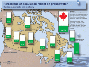
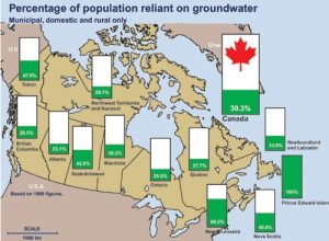
Groundwater is an important resource — especially if you live in PEI — as the graphic below indicates:
(Courtesy Environment Canada)
In Canada, 8.9 million people, or 30.3% of the population, rely on groundwater for domestic use. Approximately two thirds of these users live in rural areas. In many areas, wells produce more reliable and less expensive water supplies than those obtained from nearby lakes, rivers and streams. The remaining users are located primarily in smaller municipalities where groundwater provides the primary source for their water supply systems. For instance, 100% of Prince Edward Island’s population and over 60% of the population of New Brunswick rely on groundwater to meet their domestic needs.
Worth reflecting on …
Check out this video clip “Does science threaten belief in God: The Environment”: http://www.youtube.com/watch?v=OSavip0EAhM&list=PL99B2AA9CE8133639
For a really thorough introduction to all sorts of topics related to the Bible and Science, visit the information page on the American Scientific Affiliation website: The Bible and Science Page: all sorts of topics and perspectives (the editors’ have no axes to grind) are listed here. Check them out!
In particular, I encourage you to follow the link to Science and the Bible: Are They Incompatible? by Ernest Lucas (from Science and Christian Belief, Vol. 17, No. 2, October 2005, pp. 137-154.
How do you feel about the authors’ comments? Do you agree? Feel free to discuss this quote on the course discussion site (see the syllabus for details …)
To review …
Check out the resources at www.masteringgeography.com.
This page is the intellectual property of the author, Bruce Martin, and is copyrighted © by Bruce Martin. This page may be copied or printed only for educational purposes by students registered in courses taught by Dr. Bruce Martin. Any other use constitutes a criminal offence.
Scripture quotations marked (NLT) are taken from the Holy Bible, New Living Translation, copyright © 1996. Used by permission of Tyndale House Publishers, Inc., Wheaton, Illinois 60189. All rights reserved

