Oceans, Coastal Processes and Landforms
Geosystems, 4CE, pp. 490-505 (Geosystems, 3CE, pp. 483-497)
“O LORD God Almighty!
Where is there anyone as mighty as you, LORD?
Faithfulness is your very character.
You are the one who rules the oceans.
When their waves rise in fearful storms, you subdue them.
You are the one who crushed the great sea monster.
You scattered your enemies with your mighty arm.
The heavens are yours, and the earth is yours;
everything in the world is yours–you created it all.”
Psalm 89:8-11 NLT
**There is a video version of this lecture here: https://youtu.be/AABQaGmEUkE
**The exam is based on the content in these notes, so please print them off to study from.
 Oceans cover approximately 70% of the Earth’s surface. This percentage appears to have changed as sea level has changed throughout Earth’s history: currently sea level is estimated to be 200 metres higher than during the last ice age. There is evidence that at times past, sea level was much higher than present and/or that mountains were lower than present … The Earth is a dynamic environment in which, over billions of years, things have changed dramatically.
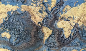 Oceans are deepest in trenches which appear to be associated with tectonic subduction zones; the deepest are in the Pacific Ocean, off the coast of Asia (remember plate tectonics in Chapter 13 4CE, Chapter 12 3CE). These may seem counter-intuitive. We tend to assume oceans would be deepest in the middle. In fact, due to subduction under continental plates they are often deepest just offshore and, due to new crustal formation where plates are spreading, they are relatively shallow in the middle.
Seawater is a solution composed of water and dissolved elements, principally:
- Chlorine (Cl) and sodium (Na) – i.e. NaCl or salt
- Other chemicals including magnesium, sulphur, calcium, potassium, and bromine
- Water does dissolve 57 of the 92 naturally occurring chemical elements (remember the periodic table of the elements?), so most naturally occurring chemical elements are found in sea water, although in very small quantities.
- Commercially, salt (NaCl), magnesium, and bromine are “mined” from sea water.
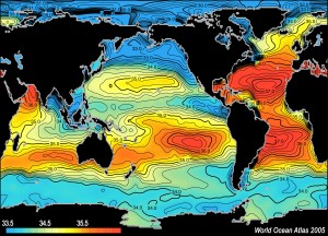
The global average percentage of these dissolved elements is approximately 3.5% or 35 parts of dissolved elements per thousand parts of water.
- Brine refers to water that has a higher concentration of dissolved chemicals than 3.5%. Typically this occurs in tropical and subtropical regions where there is much evaporation from the oceans (the dissolved minerals do not evaporate, thus their concentration increases as water evaporates). The Persian Gulf, for instance, has a salinity of 4.0% because of high evaporation and little precipitation.
- Brackish refers to water that has lower concentration of dissolved chemicals than 3.5%. Typically this occurs in more northerly or more southerly waters (less evaporation), particularly where large rivers or much runoff introduces large amounts of fresh water into the ocean, diluting the salinity of the ocean water. The Baltic Sea (northern Europe), for instance, has a salinity as low as 1.0%
For more on seawater salinity and a map of global salinity.
I. Ocean Structure
A. Physical Structure
Define and know Figure 16.4 4CE, p. 495, “The ocean’s physical structure” (Figure 16.2 3CE, p. 487):
- Mixing zone: the surface area, where heat from the sun and atmosphere and the mixing effect of winds influence the water properties.
- Thermocline transition zone: the temperature decreases with depth. This zone is only marginally influenced by surface heating and movement (wind).
- Deep cold zone: water is near 0°C and is unaffected by any surface weather or movement — cold, dark, and still … always!
 B. Ocean Currents
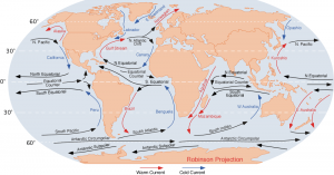
An ocean current is a continuous, directed movement of seawater generated by forces acting such as wind, the Coriolis effect, and local topography. For today’s ocean currents, click on this excellent website.
On the ocean surface, currents (flows of water in one direction) are caused by wind stresses on the upper layers of the ocean. Wind friction results in water movement in the top 100 metres.
Because of the effect of the earth’s rotation, currents move at right angles to wind direction; to the right in the northern hemisphere and to the left in the south. (Figure 6.18, “Major ocean currents”, 4CE, p. 165 (3CE, Fig. 6.20, p. 155)
In general, surface currents direct water from the equator to the poles .
 Deep ocean currents provide the feedback mechanism by which water is redirected toward the equator. Water travels back toward the equator along the ocean floor (Figure 6.20, “Deep ocean circulation”, 4CE, p. 168 (3CE, Figure 6.22 p. 159)). This global movement of warm surface water poleward and deep water movement from the poles toward the Equator is called the thermohaline circulation. It is often described as a global conveyor belt.
You don’t need to know all the details. Do know that surface currents tend to move warm water poleward (this has major climate influences) and deep currents tend to move cold water back toward the Equator
C. Ocean Zones
- Ocean Basins – refer to open ocean areas, 3-6 kilometres deep, typically underlain by younger, thinner crustal material than the continents.
- Continental Slope – refers to the steep slope at the edge of most continents where the seabed drops to deep water.
- Continental Shelves – refer to relatively shallow underwater extensions of the continents from the coast to the continental slope (approx. 200 m deep). (e.g. Grand Banks off Newfoundland)
- Littoral zone (Latin for “shore”) extends from:
- the deepest point in the ocean where storm waves can disturb the ocean floor (normally a depth of about 60 m)
to
- the highest point on the shore that storm waves can reach.
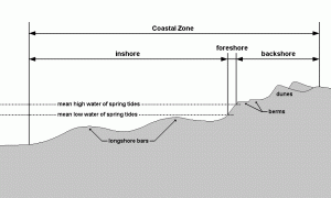 See Figure 16.5, 4CE, p. 498 “The littoral zone” (Figure 16.3 3CE, p. 488). This is where the majority of landforms are actively being formed and modified by weathering, mass wasting, and erosion.
D. Tides
Tides refer to the rhythmic daily rise and fall of the ocean surface.
Tides vary from as little as 1 metre (in the Mediterranean Sea) to 15.5 metres in the Bay of Fundy (and its arm, the Minas Basin) … cool animation of high and low tides in the Bay of Fundy, and the example of Scott’s Bay, NS. How high tides will be (the difference between high and low tide) is predictable because they are caused by physical forces – especially the relative position of the sun – earth – moon.
Study Figure 16.6, “The cause of tides”, 4CE, p. 499 (3CE, p. 491)!
Simply put, the ocean waters respond to the gravitational pulls of the moon (primarily) and the sun (secondarily):
- the moon’s gravitational pull counteracts the earth’s gravitational pull at two points:
a. at the point on the earth’s surface directly beneath the moon
b. at the point on the earth directly opposite (a)
2. at these two points water is less tightly held to the earth and “bulges” away (we describe this as a “high tide”).
3. because the earth rotates on its axis and the moon revolves around the earth, these points of high tide are constantly changing; moving at a rate of 3000 km/h.
4. it takes 24 hours, 30 minutes for the moon to return to the same point above the earth; during that time two tidal rises occur:
a. one when the moon is directly overhead, and
b. one when the moon is directly opposite.
5. but tides are not of a constant magnitude. Over about a 28 day cycle, tides vary from a maximum high tide, to a minimum high tide and back to a maximum high tide. This is due to the influence of the sun’s gravitational pull.
 6. when the sun and moon are pulling together (full and new moons), the greatest gravitational forces are at work and the greatest tidal ranges occur (spring tides … animation). A tide that occurs when the difference between high and low tide is greatest; the highest level of high tide.
See Figure 16.6, examples a and b.
7. when the sun is pulling at right angles to the moon (1st and 3rd quarters of the moon), gravitational effects are somewhat balanced, resulting in minimum tidal ranges (neap tides … animation). A tide that occurs when the difference between high and low tide is least; the lowest level of high tide.
See Figure 16.6, examples c and d.
8. tidal ranges are also strongly influenced by local sea bed and coastal landforms.
In reality, ocean tides are not quite so simple. If our planet had no continents, tides would simply be bulges of water moving westward with the moon and sun. Because of land masses, however, tides are actually a complex system of rotating and trapped waves. In the North Atlantic, waves mainly rotate anti-clockwise, with small rises in the middle of the ocean and higher amplitudes around coastlines, especially in northwest Europe and Britain. Here is an amazing video of actual tides created by NASA: Global Ocean Tides (NASA). The data used in this visualization run for slightly longer than one Earth day.
In areas with substantial tides tidal power has been explored as a power generating option (e.g. Bay of Fundy). This has substantial environmental impact, however, because a dam has to be built across the mouth of a bay. This does interfere with fish and other marine life which raises environmental concerns. See Figures 16.7 and 16.8 “Tidal range and Tidal power” (4CE, pp. 500-501; Fig. 16.7 3CE, p. 492).
II. Littoral (Coastal) Systems
In this course we will focus on the littoral (coastal) zone. Within most littoral (coastal) environments, there are four main zones:
- Offshore zone – where wave action does not reach sea floor
- Nearshore or Inshore zone – where waves energy reaches the sea floor
- Foreshore zone – where waves start to break
- Backshore zone – above normal wave activity
Identify and study these four zones on Figure 16.5 4CE, p.498, “The littoral zone,” (Figure 16.3 3CE, p. 488).
-
Offshore Zone
Coastal processes are driven by water moving landward in the form of waves. Waves are, in turn, generated by wind. Wind, moving over the water surface, sets up an oscillation within the water; individual water particles move in a circular manner. (See Figure 16.9, “Wave formation and breakers,” 4CE, p. 502 (Fig. 16.8; 3CE, p. 494)).
Water particles themselves do not travel forward with the wave; the energy of the wave is transmitted from one particle to another, causing the wave (but not the actual water molecules) to move forward (Note “path of water particles” on Figure 16.9a/16.8a). The water, itself, does NOT move forward with the wave in the open ocean/offshore zone! Only the energy moves forward, transmitted from water particle to water particle
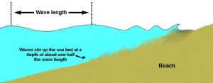 Waves are described in terms of:
- fetch: stretch of water over which wind blows to create wave action
- wavelength – horizontal distance between crests (related to wind speed/fetch)
- height – vertical distance from wave crest to wave trough
See Figure 16.9a/16.8a, 4CE, p.502 (3CE, p. 494)!
In the offshore zone, waves have no effect on the sea floor. They manifest themselves as swells, rounded undulations. Waves normally do not “break” unless severe winds push the tops over.
-
Nearshore Zone
Waves begin to affect the sea floor when the water depth is less than half of the wavelength. At this point the horizontal (forward) movement of the wave energy is impeded by friction with the floor.
As a result, the wave moves faster at the surface and slower on the sea floor, causing the wave to “pile up” (decreasing wavelength, increasing height), and ultimately fall over on itself (break). These waves are breakers. As waves break, the water particles themselves actually move forward, in the nearshore zone.
Within this zone, fine grained sediment on the sea floor may be moved landward, resulting in a rocky bed.
-
Foreshore Zone
When a wave breaks, the oscillating motion of the particles gives way to forward motion; the wave (including the water) runs landward, spending its energy as it counteracts the forces of gravity and friction (with the beach) and as it collides with the backwash of other waves.
In this zone, waves move in distinctive ways:
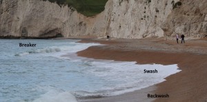
- as incoming waves – breakers – and swash (the water that “runs” up a beach after a wave has broken)
- as outflowing water – backwash – the water that “runs” down the beach back into the ocean.
- as rip currents – localized, faster flowing currents cutting back through the foreshore zone (up to 1 m/s);
- as longshore currents – water moves laterally down the coast because waves hit at an angle, or to counteract the effects of local topography. One consequence is the longshore or beach drift of sediment (as much as 30 cm/s to 120 cm/s). Annually 200,000 cubic metres of sand is moved by this process at Santa Barbara, CA; 40,000,000 cubic metres in the Netherlands.
- wave refraction – waves are “bent” by coastal topography. Where incoming waves strike the shore at an angle, they bend parallel to the coast due to friction with the shore.
See Figures 16.10 “Wave refraction and coastal straightening” and 16.11 “Longshore current and beach drift,” 4CE, pp. 503-504 (Fig. 16.9 and 16.10; 3CE, pp. 495-6).
-
Backshore Zone
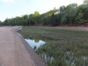
This zone is above the normal effect of wave activity (see the backwater salt marshes on Brier Island, NS, right). However during strong winds and severe storms it may be influenced by wave activity.
Read the section on tsunamis and seismic sea waves. We introduced these in Chapter 13/12. Note: tsunamis are not “tidal” waves at all. They are caused by earthquakes and thus seismic sea waves. Tides have nothing to do with them!
III. Coastal Landforms
A. Landforms of Erosion
![16 sea cliff[1]](https://rossway.net/wp/wp-content/uploads/2015/10/16-sea-cliff1-300x298.gif) Study Figure 16.13, 4CE, p. 508 (Fig. 16.12; 3CE, p. 498), “Erosional coastal features.”
Study Figure 16.13, 4CE, p. 508 (Fig. 16.12; 3CE, p. 498), “Erosional coastal features.”
Erosional coastlines — coasts that are characterized by landforms sculpted by erosion (as opposed to deposition) — are typical of west coasts in northern, mid-latitude regions (like North America and Europe). In these regions the dominant winds are westerlies, exposing the coastlines to numerous, high-energy storms. Consequently the coastlines are rugged, heavily eroded by wave actions, and depositional landforms (like beaches) can be few and far between.
Landforms on coastlines with much erosion include:
-
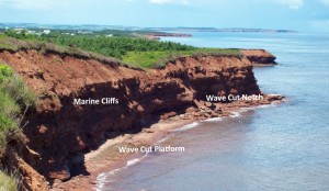
- Marine cliffs – formed by water, suspended sediment and, rocks and boulders that are pushed by wave action (especially during storms) against the cliffs. Also, the repeated wetting and drying of the rock face facilitates the growth of salt crystals in cracks and joints. These salt crystals help to erode cliffs. The material eroded by either wave action or salt crystals falls at the cliff base. These rocks can then become active agents of erosion as they are buffeted against the cliff by the waves.
- Erosion is often greatest just below the ocean surface, creating a wave-cut notch at the base of the cliff. Cliffs are often “undercut” right at sea level, where eroded boulders and rocks are hurled against the cliff by waves.

Headlands and Bays, Durdle Door, Dorset UK
- As cliffs retreat because of erosion, a gently sloping wave-cut platform or shore platform (a rocky platform between the cliff and sea) often develops at sea level. This, in turn, reduces the rate of erosion on the cliff itself.
- Because of variations in the intensity of waves or in rock resistance to erosion, some coastal areas may erode more quickly than others. A headland-and-bay coastline develops. Typically the headlands are rocky outcrops while the bays contain beaches formed of fine material eroded from the headlands
- Marine caves and arches – where weaknesses occur in massive rocks (due to cracks, joints, or material with little resistance), caves or arches may create dramatic features.
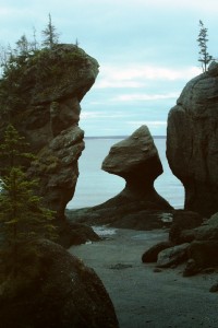
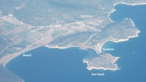
- Sea Stacks – are isolated outcrops of resistant rock. New Brunswick’s Hopewell Rocks (flowerpot rocks) – right – are sea stacks, with dramatic wave cut notches at the base.

Coastal Features, Old Harry Rocks, UK
B. Landforms of Deposition
Depositional coastlines — coasts that are characterized by landforms created by deposition (as opposed to erosion) — are typical of east coasts in northern, mid-latitude regions (like North America and Europe). Because the dominant winds are westerlies, these coastlines are more sheltered. This does not mean they cannot get occasional violent storms! But overall, the weather is less stormy. Typically east coasts also have larger rivers than west coasts, bringing more sediment which can be used to create depositional landforms.
Landforms on coastlines with much deposition include:
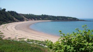
Beaches are formed by the deposition of sediment from actively eroding marine cliffs, from material transported by rivers and wind, and by storm waves scouring the ocean bed.
This sediment (from fine sand to large stones), is shaped by swash and backwash into wedge shaped deposits, beaches. Beaches always form at the head of bays. The sediment is washed down from the headlands toward the end/head of the bay.
Beach Profiles
The shape and character of a beach varies according to the type of sediment, the wave energy and local topography. However a basic pattern is evident:
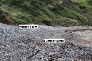
- in summer, sand and other fine material accumulates because waves are relatively low energy; the result is a low benchlike ridge called a summer berm.
- in winter, high energy storm waves often cut this back, washing away the finer sediment, leaving a higher, coarser winter berm. This is often where all the seaweed and other debris is piled up in a long line.
- during windy periods, sand may be redistributed to form dunes just inland. These often develop vegetation over time and become more and more stabilized.
Beach Sorting
Sediments tend to be sorted according to size:
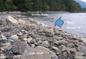
- vertically – bands of fine/coarse sediment often run the length of the beach, in response to the variable wave/water energy
- laterally – due to wave refraction and longshore drift, waves tend to move finer material and leave coarser material behind. On a straight shoreline, coarse material is left where the waves come from; fine material is moved along.
In a bay, coarse material is left at the headlands; fine material accumulates as a beach at the head. See Figures 16.10 Coastal straightening” 4CE, p. 503 (Fig. 16.9; 3CE, p. 495) and Figure 16.14, 4CE, p. 509 (Figure 16.13, 3CE, p. 499) “Depositional coastal landforms…”
Bars and Spits
Study Figure 16.14, 4CE, p, 509 (Figure 16.13, 3CE, p. 499) “Depositional coastal landforms…”
Sediment moved by drift, when it comes to a bay, tends to keep going straight. This results in a spit, a narrow, finger-like ridge of sediment protruding into open water, called a barrier spit or barrier bar.
On occasion, a spit or bar may close off an entire bay, creating a lagoon. The spit which closes off the lagoon is called a bay barrier.
If a spit connects the mainland with an island, it is a tombolo.
Barrier beaches and barrier islands are long, narrow depositions of sand, just offshore, parallel to the coast. The southeastern U.S. coastline is dominated by these features
See Figures 16.16, 4CE, p. 511 (Figures 16.15, 3CE, p. 501) “Barrier island chain…”
and Figure 16.18, 4CE, p. 512 “Coastal change…” (Figure 16.16, 3CE, p. 503) “Hurricane Georges takes its toll.”
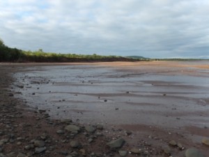
Wetlands, Mudflats and Marshes
Fine sediments which accumulate in very sheltered inlets, estuaries and behind spits create wetlands–mudflats and marshes.
Initially, the landscape simply consists of deposits of sediments – mudflats.
As time passes, vegetation may become established on these mudlfats, creating salt water marshes. These tend to further stabilize as the vegetation traps further sediment and organic material accumulates. In tropical regions these may further develop into mangrove swamps.
IV. Coral-Reef Coastlines
See Figure 16.18, 3CE, p. 504 (2CE, p. 540) “Worldwide distribution of living coral formations,”
and Figure 16.19, 3CE, p. 505 (2CE, p. 541) “Coral forms”

Distribution of coral reefs
Coral reefs develop in locations with specific criteria:
- low wave energy
- warm (20°C+), tropical waters (30°N to 25°S)
- free of suspended sediment (clear)
- rich in nutrients
Coral reefs develop as corals and algae (living organisms) secrete rocklike deposits of calcium carbonate (limestone) on the sea floor. As coral colonies die, new ones are built on top, accumulating as successive layers. Click here for a cool movie, to watch coral grow!
When coral reefs reach the surface they are actively eroded, resulting in flat top reefs covered during high tide, exposed (and eroded) during low tide. Fine, white sand beaches result from the deposited erosional material.
Coral reefs area a valuable resource as some of the most diverse and productive ecosystems on earth. They are also great tourist attractions.
- Fringing reefs are built as platforms attached to the shore. They are widest in front of headlands where wave action assures clean water and an abundant food supply.
- Barrier reefs lie offshore, separated from the mainland by a lagoon. Narrow gaps or passes occur in the reef to allow water to flow out of the lagoon, back to the ocean. They are particularly common around volcanic islands associated with mid-oceanic ridges.
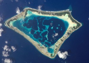
- Atolls are
roughly circular coral reefs enclosing lagoons, but without any land inside. Some atolls have developed to form coral island chains. Most of the world’s atolls are in the Pacific Ocean (such as the Tuamotu Islands, Caroline Islands, Marshall Islands, and the Coral Sea Islands) and Indian Ocean (the Atolls of the Maldives, the Laccadive Islands, and the Outer Islands of the Seychelles). The foundation of these reefs and islands is invariably volcanic rock, which has led to suggestions that they were originally formed around low volcanic islands, which, as sea level rose with deglaciation, subsided beneath the sea. Meanwhile the reefs, as living entities, continued to rise with the water level. Atolls have no rock or mineral material except calcium carbonate, thus only vegetation which requires few additional nutrients (e.g. palm trees) can grow. Fresh water is also non-existent except in the form of precipitation.
Coral reefs are fragile ecosystems — changes in any of their essential conditions (water pollution, water temperature, sea level changes) put reefs at risk. Much research is now engaged in preventing the destruction of coral reef environments.
The largest coral reef system Australia’s Great Barrier Reef is most threatened, with potentially only 5% of its surface area potentially being living coral within a few years:
- NOAA page on climate change and coral reefs
- Storms to starfish: Great Barrier Reef faces rapid coral loss: study | Reuters
- National sea simulator to offer insights into Great Barrier Reef perils | Environment | theguardian.com
Reefs in the Caribbean have also been seriously depleted due to the effects of climate change, pollution, overfishing and degradation:
Coral bleaching occurs when coral is exposed to a temperature above what it can stand for more than a month. It can expel the algae that live inside it and provide it with food. This leaves the coral a ghostly white and with no source of energy. A percentage of coral won’t re-acquire their algae and die. Over a period of time, many reefs that have experienced this coral bleaching will recover, as new corals grow, but some will be permanently lost. See Scientists racing to prevent wipeout of world’s coral reefs, Coral Bleaching event 2015
There are excellent websites on coral reefs, a great starting place with links to over 620 other organizations, visit the International Coral Reef Alliance.
V. Coastline and Ocean “Issues”
A. Preventing Beach Erosion or “Beach Nourishment” (the new “buzz” word)
People like beaches … but they are easily eroded. Wave action erodes cliffs, rocks, and sand.
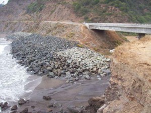
Beach protection, northern California
Consequently several strategies have been employed to protect or stabilize them.
In order to protect shorelines from erosion two approaches may be taken:
- Protective – people build breakwaters, sea walls, dikes, barriers, etc. These are very expensive and may be destroyed during storms. In areas of substantial cliff erosion, an artificially created shore platform, made of boulders or chunks of concrete, have been tried (with some limited success around Point Grey, Vancouver, for example)
- Constructive – people create features that encourage beach building processes.
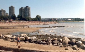
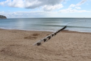
Groin, English Bay, Vancouver
The most effective of these are groins, walls built at right angles to the shore (made of wood, rock or concrete). Sand accumulates on the updrift side. If groins are placed closely together, they can create a wide, erosion resistant beach. On sandy coastlines groins (made of wood, rock or concrete), tend to restrict longshore currents and drift, “trapping” sand on the updrift side, enhancing beaches.
For a good overview of beach nourishment strategies, visit this site.
The USGS has a great Center for Coastal and Watershed Studies, too.
B. Rising Sea Levels
As global warming is occurring one of the predicted consequences will be a rise in the sea-level of a few metres, inundating low lying areas. The acceleration is due mostly to anthropogenic global warming that is driving the thermal expansion of seawater while melting land-based ice sheets and glaciers. The current trend is expected to further accelerate during the 21st century.
See NASA Sea Level Page for current measurements
This rise in sea level would occur for two reasons:
- global warming would raise the temperature of the upper layers of the ocean (to a depth of a few hundred metres) – the resulting thermal expansion would cause sea level rise
- global warming would increase the rate of continental ice accumulations, increasing the volume of the oceans. If all continental ice were to melt, sea level would rise 60 m.
Global warming has been occurring since at least 1880 . Difficulties related to local sea level variations by tides, currents, topography etc. confuse the issue. However, sea levels clearly have risen about 80 mm by 1980 (a rate of approx. 1.2 mm/year since the early 1900s), and are currently rising at an accelerated rate of 2.4 mm/year.
Sea level in some parts of Atlantic Canada has risen 30 cm in the last 100 years. Homes, cottages and other infrastructure built near the coast are increasingly vulnerable to flooding as sea level rises and more frequent and intense storms batter the coastline.
Future projections of these rates, however, vary greatly. For instance, global warming also would result in more precipitation, causing glacier and ice-cap growth, balancing out sea level rise?
Average estimates, however, suggest a further 1 m rise by the mid-21st century, causing serious problems for major coastal cities, loss of vast amounts of agricultural land, flooding, and the exposure of inland areas to severe maritime storms.
The cost of protective dikes etc. is enormous. They may or may not be effective anyway.
One positive note – if reef-building corals keep up by intensifying their rate of growth (as they appear to do, their increased production of calcium carbonate would reduce the carbon dioxide in the atmosphere, slowing the rate of global warming. If the corals could not keep pace, however, they could become extinct.
Future trends are unclear … so are future consequences and responses.
C. Warming Temperatures
With climate change, ocean temperatures are rising: 2017 Was the Hottest Year for the World’s Oceans – Latest Stories
This has several consequences including the potential for
- more intense hurricanes (see Chapter 11 or take the other course!) and In a Warming World, the Storms May Be Fewer But Stronger (NASA)
- changing ecosystems
- A swordfish and a loggerhead turtle in B.C. coastal waters? Scientists say warming seas are to blame (2018)
- Record warm ocean temperatures pose threat to B.C. salmon (2017)
- Warming Oceans Drive East Coast Fish to Cooler Waters (Scientific American)
- Warming Waters Could Shift Salmon, Other Species on West Coast (Scientific American)
D. Coastal Flooding
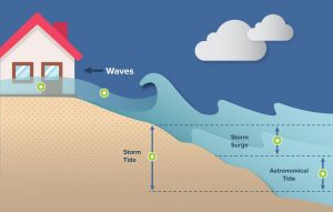
Coastal flooding is a regular occurrence along Canada’s coasts, the St. Lawrence and the Great Lakes. It can be caused by storm surge, large waves and high tides.
Storm surge happens when the wind associated with a major storm pushes water onto the coast. This may damage coastal infrastructure and threaten human health and safety. Large waves associated with the storm may drive additional water onshore, worsening impacts.
At times, even higher-than-normal tides can cause or contribute to coastal flooding. Coastal infrastructure in most areas is built higher than the highest predicted tide for that area. This value is known as “Highest Astronomical Tide” or HAT. Damage to coastal infrastructure typically occurs when water levels rise higher than a location’s HAT. However, if infrastructure is built below HAT, high tides alone may damage infrastructure and threaten human safety. This is especially true of unusually high tides such as spring tides, also known as king tides. Spring tides happen when the gravitational pull of the sun, moon and earth align.
If storm surge, large waves and high tides happen together, the impacts to affected areas may be significant. However, even just one of these contributing factors can cause flooding along the coast. Other factors like sea or lake ice being pushed onshore can magnify the impacts of a coastal flood.
The effects of coastal flooding can be significant and may threaten the health and safety of Canadians. They can disrupt the economies of coastal communities and cause lasting damage to coastal environments. As global sea levels rise and extreme weather intensifies, the severity of coastal flooding events in Canada is expected to increase.
E. Ocean and Beach Pollution
Pollution is an increasing concern in oceans and coastal environments.
- Beach Pollution tends to come from
- Wet weather discharges resulting from precipitation, such as rainfall and snowmelt. They include storm water runoff, sewer and sanitary sewer overflows. Storm water runoff accumulates pollutants such as oil and grease, chemicals, nutrients, metals, and bacteria as it travels across land. Sewer overflows contain a mixture of raw sewage, industrial wastewater and storm water, and have resulted in beach closings, shellfish bed closings, and aesthetic problems.
- Trash and other solid material that reach rivers, bays, estuaries and oceans eventually wash up on beaches. This includes plastic bags, bottles and cans, cigarette filters, bottle caps, and lids.
- Ship discharges. Discharges from all kinds of vessels are a source of pollution that can affect beaches. Such discharges include trash, fishing gear, ballast water, and water from sinks and showers.
- Ocean Pollution comes from many sources including boats, discharges from rivers, and debris from storms, hurricanes, etc. Plastics are a particular concern. Plastics tend to concentrate in “gyres” vast circular currents in the centre of oceans (below).
- The Great Pacific Garbage Patch is a vast area of more than 79,000 tonnes of ocean plastic in a 1.6 million square kilometre area of the North Pacific Ocean, between Hawaii and California, mostly composed of microplastics less than 0.5 cm in diameter (Great Pacific Garbage Patch is 16 times bigger than previously estimated)
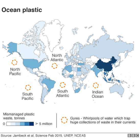
- The Great Pacific Garbage Patch is a vast area of more than 79,000 tonnes of ocean plastic in a 1.6 million square kilometre area of the North Pacific Ocean, between Hawaii and California, mostly composed of microplastics less than 0.5 cm in diameter (Great Pacific Garbage Patch is 16 times bigger than previously estimated)
Worth reflecting on …
Matthew Arnold, a Christian poet in the late nineteenth century wrote a poem entitled “Dover Beach” in which he struggles with the tension between science and Christian faith evident in his day (the Victorian / early Darwinian era). How does this poem illustrate the conflict between science and Christian faith? In what way are the troubled thoughts of Arnold (and Sophocles) like the sea? What hope does he see? How is this poem relevant to us today (consider the last stanza!)?
Dover Beach
The sea is calm to-night.
The tide is full, the moon lies fair
Upon the straits; -on the French coast the light
Gleams and is gone; the cliffs of England stand,
Glimmering and vast, out in the tranquil bay.
Come to the window, sweet is the night air!
Only, from the long line of spray
Where the sea meets the moon-blanch’d land,
Listen! you hear the grating roar
Of pebbles which the waves draw back, and fling,
At their return, up the high strand,
Begin, and cease, and then again begin,
With tremulous cadence slow, and bring
The eternal note of sadness in.
Sophocles long ago
Heard it on the Aegean, and it brought
Into his mind the turbid ebb and flow
Of human misery; we
Find also in the sound a thought,
Hearing it by this distant northern sea.
The Sea of Faith
Was once, too, at the full, and round earth’s shore
Lay like the folds of a bright girdle furl’d.
But now I only hear
Its melancholy, long, withdrawing roar,
Retreating, to the breath
Of the night-wind, down the vast edges drear
And naked shingles of the world.
Ah, love, let us be true
To one another! for the world, which seems
To lie before us like a land of dreams,
So various, so beautiful, so new,
Hath really neither joy, nor love, nor light,
Nor certitude, nor peace, nor help for pain;
And we are here as on a darkling plain
Swept with confused alarms of struggle and flight,
Where ignorant armies clash by night.
[1867]
How do you feel about Arnold’s insights? Do you agree? Feel free to discuss this quote on the course discussion site (see the syllabus for details …)
Have a look at these clips with physicist, David Wilkinson:
- Is Science useful as part of an exploration of Christianity? http://www.youtube.com/watch?v=Uxgh4f4b9Bg&list=PLB3B77E1AA52C13B5
- Difficulties with Faith and Science http://www.youtube.com/watch?v=NP8vZba0Aos&list=PLB3B77E1AA52C13B5
To think about these issues further:
Rebecca Watson writes: “It is easy to forget that we human beings are not the be all and end all of God’s magnificent creation. From one perspective we are simply creatures in it. From another perspective we are unique in his creation in being made in the image of God (Gen. 1:27). However, both the beauty and abundance of marine life and the biblical passages concerned with the sea show that the oceans and the life in them are of intrinsic value to the creator. Perhaps the best passage illustrating this is from Psalm 104.
There is the sea, vast and spacious,
teeming with creatures beyond number – living things both large and small.There the ships go to and fro,
and Leviathan, which you formed to frolic there …”
(Dr Rebecca Watson is a Research Associate at the Faraday Institute, Cambridge, working on ‘The sea in Scripture’, conducting a study of the biblical material on the oceans in order to develop a biblical theology of the sea. The aim is to apply this to how Christians should treat the ocean, the creatures living in it and the resources it contains.)
To review …
Check out the resources at www.masteringgeography.com
This page is the intellectual property of the author, Bruce Martin, and is copyrighted © by Bruce Martin. This page may be copied or printed only for educational purposes by students registered in courses taught by Dr. Bruce Martin. Any other use constitutes a criminal offence.
Scripture quotations marked (NLT) are taken from the Holy Bible, New Living Translation, copyright © 1996. Used by permission of Tyndale House Publishers, Inc., Wheaton, Illinois 60189. All rights reserved

